For my latest excursion I took a trip out last week to a destination that lies outside of Nottingham city centre but is easily reachable by public transport. I knew I was taking a risk as the location in question has garnered something of a reputation, not always for positive reasons, but I was eager to see whether this has had any kind of an effect on the local drinking scene. The destination of which I speak ended up not being as bad as I was concerned it could be and provided an intriguing afternoon out. This is the story of my trip to Bulwell.
Bulwell is a market town about 4.5 miles (7 km) northwest of Nottingham city centre, on the northern edge of the city. The United Kingdom Census 2001 showed there were almost 30,000 people living in the Bulwell area, accounting for over 10% of the population of the city of Nottingham. The 2011 census showed a population of 16,157 in the Bulwell ward of Nottingham City Council. There is also an adjacent ward called Bulwell Forest. The population of this ward at the same census was 13,614.
The earliest documented settlements in Bulwell appeared circa 800 A.D, and were most likely built around the same time as the first local bridge spanning across the River Leen. With the river being significantly narrower, shallower and slower-moving in Bulwell than in other potential locations along its length and the threat of highwaymen a very real danger on existing cross-country routes, a toll bridge was constructed in this outpost, allowing for a quicker and safer passage from north to south for travellers but providing an obstacle to less legitimate travellers.
The bridge created a rare direct road to Nottingham from the North West and therefore introduced regular traffic from across the country to the area for the first time.
The tolls levied for crossing the new bridge required the building of a gatehouse for those collecting the levies and providing protection for people using the route: the creation of the toll house thereby inadvertently founding the new settlement. The almost captive market of the travelling parties provided endless potential for trade, and the abundance of natural resources made it easy to erect a dwelling. As the volume of traffic using the road increased, so did the size and population of Bulwell.
Bulwell is mentioned in the Domesday Book, which was compiled in 1086. Recorded in the book as "Buleuuelle" and classified as a village, Bulwell had by this time become established as a small trading post for all kinds of goods and services. It had expanded to cater both for those living and working in the surrounding area and those travelling further afield, and this in itself encouraged many others to settle in the wider area.
Local people, particularly the poorer of the new settlers, often offered space in their homes to travellers requiring overnight stops. Paying a relatively small price, travellers would share a home-cooked meal with their hosts and sleep in their rooms - a much safer and infinitely more sociable arrangement than continuing onto Nottingham. The river provided local entrepreneurs with the facilities to make beer, a fact which it appears was exploited freely, and which perhaps led more 'guests' to become overnighters inadvertently and require accommodation!.
Never slow to evolve, by around 1200 Bulwell had grown to provide all the facilities to accommodate animals and their masters alike in droves, becoming something of a one-stop 'service station' on what was fast becoming a relatively major road. Trade in this still relatively small and compact stopping post thrived, with a steady stream of newcomers attempting to exploit the opportunities Bulwell had to offer. Whilst the increase in trade was good for the local economy, the new-found abundance of salesmen and tradesmen split the town in two.
The owners of the 'official', original businesses, having in some cases incurred large expense to build and maintain premises, complained bitterly about an ever-growing number of roaming salesmen undercutting their prices and taking their trade. Since they were also paying rates to the local landowner, they considered their right to monopolise custom inalienable. In response to the complaints, a local law was enacted (circa 1320 AD) forbidding anyone without 'fixed... and at least part-covered premises' from selling goods or services close to the original businesses.
However, the statute was badly worded: to circumnavigate the laws, the salesmen simply fixed posts into the ground, creating market stalls similar in design to their modern counterparts. The stalls were covered for use and left uncovered in situ when not in use, thus both abiding by the law and designating a permanent venue for their sales. The people using these facilities fought hard against the power of the richer businessmen and successfully defended the right of the marketeers to operate alongside them. The location of the Market Place remains virtually unchanged to this day and still houses a bustling market on Tuesdays, Fridays and Saturdays.
The population grew steadily throughout this period, but the town itself did not grow much in size: opportunities for betterment and the desire of many to live further away from the 'unhealthy' town centres ensured a relatively even flow of traffic in and out of Bulwell.
At some point during this time, both the magnesium limestone and the sandstone (now known as Bulwell Sandstone) on which Bulwell sits began to be quarried. The strong easily crafted durable rock, a dull yellow-orange magnesium limestone (not to be confused with the Bunter sandstone famously underlying Nottingham Castle), provided a perfect building material which was also easy to quarry. Many houses, schools, churches and - particularly - garden walls built using Bulwell Stone still stand to this day, extending for miles around Bulwell in all directions. An early example can be found in sections of the wall surrounding Wollaton Hall, which was built using Bulwell stone in the late 16th century. The sheer quantities used there - and elsewhere in the city - suggest some kind of professional mining operation must already have been in operation by this time. Bulwell stone was later also used to repair the damage caused to the palaces of Westminster during the second World War.
Coal is also found in abundance close to Bulwell. Running as part of much larger seams criss-crossing the region, the coal lies underneath the layers of sandstone and is in places only a few feet beneath the surface. Coalmines in the area around Bulwell were therefore among the first in the county to operate on a commercial basis, with large-scale mining from around 1500 onward.
Many fortunes were made at the time from the extraction of coal, including that of Sir Francis Willoughby. Willoughby paid for the building of the extravagant Wollaton Hall (mentioned above) with money obtained through coal-mining. One of the world's first railway lines, completed in 1604 and leading between nearby Strelley and Wollaton, was built by Willoughby's heir to aid transportation of the tons of coal being produced from 'his' mines. Since the invention of the steam train was still some 200 years in the future, horses and other beasts of burden were used to pull the rows of carts filled with coal, with the rails acting more as a guide and as a smoother surface when compared with the roads of the time.
The church on the hill overlooking Bulwell (built 1849-1850) is on the site of the original Bulwell church, which dates back to at least the 13th century. Towering over most of North-East Nottingham, Bulwell Saint Mary the Virgin and All Souls (known simply as St Mary's) can be seen from many miles away, and its bells still ring out across the area each weekend.
In 1667, George Strelley "built a school for the educating and teaching (of) young children of the Inhabitants of the said Parish", a stunning building that survives to this day, along with many of the other houses built at this time. The building is now used as a private home but retains many of the original features. 1852 brought the act of Parliament allowing for the extension of the gas pipeline from Basford and the South. This allowed for street lighting, commercial and domestic use, and effectively revolutionised life in the town. The earliest supply of water was not to arrive until 1877, with the many local springs, wells and the river providing for the needs of both business and domestic use until this time. Before 1877, water-borne diseases were rife and the river water highly polluted by both industry and sewage, leading to very high rates of infant mortality across the region. The percentage of children dying before reaching their fifth birthday decreased by over 75% in Bulwell between 1870 and 1890 - a situation that led to dreadful overcrowding and even more demand for already overstretched services like housing. Health care again suffered as a result of the insanitary living conditions, but the population continued to grow apace.
1843 brought bad weather that did irreparable damage to Bulwell Saint Mary's church. The church we have today was built in its place between 1849 and 1851; the architect was Henry Isaac Stevens. In 1885 the new church of St. John the Divine on Quarry Road was consecrated.
Over the past century, Bulwell has grown enormously with the creation of housing estates such as Crabtree Farm, Snape Wood, Highbury Vale and Hempshill Vale.
Snape Wood and Sellers Wood were originally part of a swathe of woodland that bordered the landfill site to the north-west of Bulwell, stretching down to the farmland that became Hempshill Vale estate to the south-west. Both woods were protected under Royal Warrants stretching back to the 12th century, but drastic shortage of housing in Bulwell in the 1960s and 1970s, as in Nottingham as a whole, led to the protection being removed and new housing estates being built.
A token remnant of Snape Wood was left behind in the middle of the new estate, amounting to little more than a small fenced-in copse with three pathways leading through it. Owned by the local authority, Nottingham City Council, the site was designated a Local Nature Reserve, but years of neglect have left the site rubbish-strewn and in need of a structured management plan. Despite constant fly-tipping and a lack of proactive conservation, this site surprisingly supports a wide variety of wildlife, from rare wildflowers to mammals such as grey squirrels, hedgehogs and urban foxes, as well as up to 20 different species of bird. In February 2009, plans to set up a community group to take ownership for the maintenance and conservation of the site on behalf of the local authority were moved forward.
A larger proportion of Sellers Wood remains, with the land also designated as a Local Nature Reserve, actively managed by Nottinghamshire Wildlife Trust on behalf of the local authority, Nottingham City Council. Sellers Wood was declared a Site of Special Scientific Interest by English Nature in 1981, being cited as "a fine example of broad-leaved semi-natural woodland...of regional importance".
Bulwell no longer has a working quarry, landfill site, coalmine or brewery to employ its residents. Designated industrial areas such as those found on Greasley Street and Commercial Road were constructed early in the latter half of the 20th Century, followed in the 1980s and '90s by smaller developments of offices and light industrial units such as those on Pottery Way (off Sellers Wood Drive).
The larger developments for industry built in Sellers Wood in the 1980s (off Blenheim Lane/Camberley Road/Dabell Avenue) were further added to during the 1990s. Many other industrial buildings have sprung up in the surrounding area since then and the larger area looks set to grow outwards once more in the near future. The extended industrial estate includes warehousing and distribution for national food retailers, large printing factories, office blocks of all sizes and numerous small- to medium-sized units offering a variety of goods and services. A large Cash and Carry wholesalers recently joined the supermarket, petrol station and small row of fast-food outlets between this industrial estate and the rest of Bulwell. This utilises yet another piece of the land that was used for landfill until the 1960s/1970s; leaving only two large fields now without some kind of development.
Just next to the supermarket is a very steep hill which still marks out the edges of the long-abandoned limestone quarry.
The centre of Bulwell is located in a valley next to the banks of the River Leen. The Bog area beside the Leen, known for over 900 years as "Bulwell Bogs", has long been set aside as a place where children can play, paddle and fish.
After an attempt by the Lord of the Manor to enclose the land around the Bogs, in 1872, the people of Bulwell staged a peaceful protest, massing in their hundreds to protect the 'common' land. Described as "...impeccably well behaved and peaceable to a man; indeed rather joyous of spirit!" in the official records, the people of Bulwell marched a short distance before enjoying lunch by the river. After this, the crowd is said to have "...dispersed quietly and as directed with no further disturbance", later winning the fight to designate the land for the "pleasure and leisure of the people of Bulwell".
The whole Bogs area was set to be demolished in 2002, to make way for a large road-bridge and a transport interchange, from where buses, trams, taxis and trains could all be caught. Fierce public opposition from local people resulted in a campaign being launched to prevent the work; the City Council eventually scrapped the plans. With help from local community groups and residents, the facilities at Bulwell Bogs were instead upgraded in 2003 to produce a bigger play-park, a safer paddling pool and a cleaner feel, and won a Green Flag Award in 2004 for the work done to regenerate the area.
As well as the Bogs, there is an area about a mile upstream, near the present-day Moorbridge, which historically attracted children from miles around to play. This led to the nickname "Bulwell-on-Sea" being applied by other Nottingham residents. The building of the outdoor Lido pool nearby further strengthened the connection, with families historically travelling from across the city to spend a day by the water in Bulwell. Unfortunately, despite fierce opposition by local residents, the Lido was demolished in 2006, with the land being sold off to private housing developers.
Bulwell is locally pronounced as the monosyllabic word 'Bool', which gradually formed through 'Bulwell', 'Bulwull' and then to 'Buwull'.
Local linguists have additionally suggested that by 2030, local pronunciation of the word will then have reached 'Buwuww'
The name is supposed to have been derived from the spring which runs out of the Bunter sandstone over a bed of clay, near to the northern end of the forest, called "Bull Well." In
The Place Names of Notts., it is suggested that the first part of the name may stand for an Anglo Saxon person called Bulla, or a bull, or it may describe the bubbling sound produced by the flowing water of the spring.
Legend has it that the town was named after a bull struck a sandstone rock causing it to seep water - a well. The now sealed well-housing, located in the nature reserve off Bestwood Road, is said to be the original well; i.e. the place that the bull gored. Both Bulwell Saint Mary's school and the Seventh-day Adventist church next door have illustrations of the tale relief-carved into sandstone blocks. Generations of Bulwell's children have grown up with the legend, and with the city council recently erecting a statue of a bull goring a well in the marketplace, it seems that the traditions surrounding the legend will continue indefinitely.
Bulwell has more of historical interest than I imagined and I was hoping, as I headed out on a not unpleasant afternoon, that this would extend to its pubs! I knew that Bulwell had a large number of drinking establishments but some quick research had confirmed that very few of them sold real ale. At the very least this made it easy to decide which pubs I would be visiting and I was optimistic, if a tad nervous, as I boarded the tram and began my journey. In a little under 45 minutes I had arrived at my destination and began my exploration. Following a brief survey of the town centre to get my bearings, I immediately headed to the first pub on the day's itinerary, which happened, luckily enough, to be the local Wetherspoons, the William Peverel.

Opened in 2011, having been converted from its previous life as a Wilko, the pub is named after the son of William the Conqueror who, according to the Domesday Book, owned land in the area and was responsible for the construction of Nottingham Castle. The interior is impressive, with a high, vaulted roof over the main room and clerestory windows. The décor is natural oak timber and cream painted with a long, single bar to the front and a number of smaller rooms leading off. Numerous styles of seating and tables occupy the large central space and the main room has been designed to look like a baronial hall, complete with a carved knight on horseback. There is an outdoor smoking and drinking area to the rear. The bar features 10 handpulls, 9 of which are in use on my visit offering Doom Bar, Ruddles, Abbot Ale and doubles of Nottingham Rock Mild, Magpie Best and Derventio Cupid. I opted almost instantly for the Cupid, from Derby based Derventio. At 4.1%, this is a golden, honey ale with a smooth, rounded character. Brewed with blossom honey, Challenger and Gosling hops, it's a sweet and refreshing pint and a good way to start the day. It was lunchtime by the time I arrived and the pub was busy but I was able to find a table towards the rear, near to the kitchen, with a view through the service hatch. My pint was delicious and I enjoyed every sip as I pondered what else I was likely to expect for the afternoon. My next task became deciding where to go next.
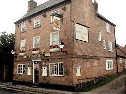
Heading out of the pub after finishing my beer, I took a left and made my way towards the top end of the high street, passing a pub on my left called the Framesmith's Arms which, although equipped with handpulls, had no ale available at the time. Reaching a KFC, I turned right, crossed a level crossing and found my next destination on my right. My attention now turned to the Newstead Abbey.
Built in the 1880s, this is a former Shipstone's house with a heritage interior that CAMRA rates as Regionally Important. Built of brick, with a corner tower the interior is partially opened out but retains much of the original structure and has 2 large rooms downstairs (one with a pool table) and an upstairs function room. From the corner entrance, on the left is a large, plain bar with island servery and a wide corridor with seating behind. Off this corridor, to the right is an opened out snug with now unused bell pushes. In 1883, this unusually laid out pub was registered as a beerhouse under Jas. Terry. The pub was registered as an Asset of Community Value in March 2016. I got slightly confused with the layout when I first entered and, having eventually found the correct door, I ended up in the bar area, which features a long bench and tables along one wall with carpeting throughout and black tiling near the bar. There is a trophy cabinet against the far wall, holding the spoils of the pool team's victories. The small bar boasts a single handpull which, on this occasion, features Marston's EPA. The very friendly landlady welcomed me and poured me a pint of this beer which was very well kept and tasty. I took a seat on the aforementioned bench and took in my surroundings. I was told by the landlady that a refurb is currently underway which bodes well for the pub's future. The overall feel is similar to that of drinking in somebody's lounge but in a good way and I can understand why the local community is determined to preserve this pub. I was preparing to move when one of the window cleaners that carries out services for the company I work for randomly turned up and the landlady offered me another pint which, at this stage, it would have been rude to turn down. As much as I was enjoying some work-related conversation, there was yet more exploring to be done and so I made my exit.
From here, I retraced my steps and made a slightly different route back to where I started passing a couple of ale-less pubs on the way. The destination I had in mind was a little bit further out and I walked past Bulwell Bogs and took a right onto Sellers Wood Drive, following this road all the way to the end where my final stop of the day is located. I had now arrived at The Limekiln.
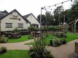
Built on the site of a former lime kiln, which previously formed a prominent part of local industry, this is a large, modern, open-plan pub operated by Marston's. The interior is large with a number of smaller alcoves. In its pre-pub days in the 19th century, Irish agricultural workers were noted for holding illicit cockfights in the area. No cocks or Irishmen were visible on the day of my visit and so I made my way to the large, J-shaped bar where 3 handpulls greeted me with a choice of Hobgoblin, Hobgoblin Gold and Marston's Pedigree. I was immediately drawn to a choice between the 2 Hobgoblins and I was swayed with the Gold, especially given that it was being sold for £1.50 a pint! The beer was very tasty and I took it over to a table underneath a window, looking out into the pub. This was again a pub that was quite busy, given that it was approaching late afternoon. The atmosphere and feel of this place was very welcoming and friendly and reinforces the fact that Marston's certainly do know how to look after their beers. And with the last drop of beer, my trip to Bulwell was complete!
It had been an interesting afternoon. The pubs providing real ale are few and far between but these chosen few are at least doing a good job with their beers. The town itself is clearly well catered for in terms of drinking dens and these obviously do enough business that they feel that real ale is not for them for whatever reason. It will be interesting to see whether or not tastes will change in future and an influx of real ale will occur in this area of the county. I suspect this may not happen soon and so, for now, the trio I experienced on my trip are the ones leading the way for real ale in Bulwell. We shall see what the future holds.